
Fyrdesnipa Peak
This is a full day hike that takes you to the top of mount “Fyrdesnipa” , 1455 metres above sea level and is considered to be of medium difficulty and anybody in reasonable good shape can accomplish this tour. We assure you that the panorama that unfolds as you ascend the top is a generous compensation for the sweat and the toil it is to get up. Since half the tours is off-trail we recommend good hiking boots, furthermore a good jacket and a cap should always be in you rucksack as the weather in Western Norway changes fast.
That you need a solid lunch packet as well as something nourishing to drink goes without saying. We also recommend you to include a pair of binoculars as a closer look at the panorama from the top is quite rewarding, furthermore a map always makes the tour safer and more interesting. Here are some directions to find you way, on the back of this page you will also find a map on which the trail you want to follow is marked in red.
From the hotel’s parking lot turn right and after 100 metres follow the road marked “ Brekke “ ( the small village on the top of the hill ). Follow the “ Brekkedalen “ road, through the gate just after Brekke ( cars must pay toll here if they want to continue ) and stay on this road until you get to a bridge on you right hand side. ( 40 – 60 minutes after leaving Stalheim ) Cross the river here and stay on this road to the end of the valley. ( There is a couple of roads going off the left which you should ignore. )
At the very end of Brekkedal, just before you go in to the mountain pass that takes you into the next valley ( Jordalen ) you will see an enclosure for sheep and cows. Next to this enclosure you will see the trail you want to follow taking off to the left towards the Urdaskaret mountain pass.
This trail takes you higher and higher up into the mountains so you want to stay on this trail for about one hour. Your next challenge is to climb the mountain range on you right hand side. You must to get off the trail at some stage and find the best and easiest place to ascent the mountainside.
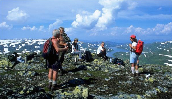
Make a halt; examine the mountainside closely and co-ordinate this with the information on the terrain provided by the map. Remember that the experienced hiker often find that zick-zacking up the mountainside is less exhausting than going straight. Once you are up on the mountain range you should find the most economical way to the peak. On the top you will command a magnificent view of the Stølsheimen mountains, surely a generous reward for your toil. ( see picture ). The easiest and fastest way to get back to the hotel is of course to back track all the way down to the hotel. ld now follow this mountain range in a northerly direction towards the peak, Fyrdesnipa.